
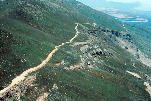
Matroosberg 4x4 Trail
Ceres
 " alt="Loading..." title="Loading" />
About Matroosberg 4x4 Trail
The Matroosberg 4x4 Trail is a self-drive trail graded between 2 and 5 and of average difficulty. There are escape routes for the more difficult areas of the trail. The trail rises to 2240 m above sea level at the Matroosberg Peak turnaround point and stretches for 30 km; six hours. This is the highest point in the Boland. The circular turnaround point is the most difficult of the trail taking you past remarkable rock formations; there is an escape route.
During winter the Matroosberg 4x4 Trail takes you over snow-covered slopes. This is a fantastic experience but more difficult than your summer drive. During the snow months there is a entry cut-off time so everyone makes it back during the daylight.
There is also a 4x2 trail heading to rock pools, a challenging 4x4 trail following the river bed and a 4x4 practice area.
Permits can be bought at the reserve and charged per vehicle and per person. Accommodation can be organised at Ceres Matroosberg Reserve
Matroosberg 4x4 Trail Map
*Distances are shown as the crow flies and not necessarily the actual travelling